Water quality modelling of the Tamar Estuary and adjacent coast
Context and Issue at stake
With a population of 250,000, a large navy presence and multiple marine industries including a rich tourism industry, the coastal environment around Plymouth is subject to multiple uses. Plymouth Marine Laboratory ‘Tamar estuary and coast operational model’ includes several Spatial Areas of Conservation (SAC) and the first National Marine Park in the UK. With the addition of a biogeochemical modelling component, we will be able to explore the impacts of multiple drivers on the marine system (e.g. eutrophication, waste water pollution), supporting monitoring efforts in the conservation areas as well as contribute to policy development and management of the multiple uses of the marine environment within the National Marine Park by stakeholders.
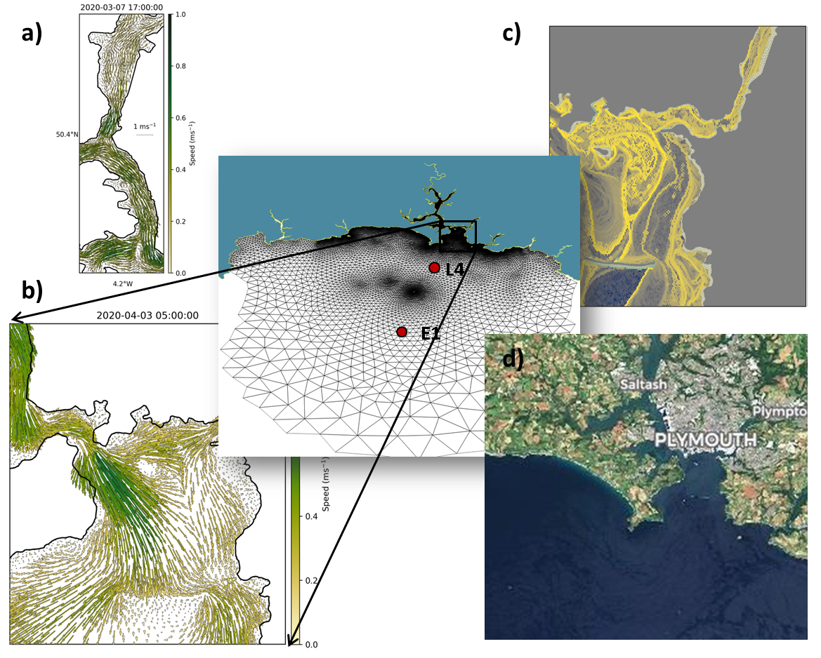
Model domain and mesh with details of the surface circulation a) in the upper Tamar, and b) in the Plymouth Sound. A snapshot of attracting Finite Time Lyapunov Exponents c) highlights the positions of frontal features that can be identified in d) high resolution Earth Observation products such as the example from Sentinel 2. The Western Channel Observatory stations L4 and E1 are also indicated.
Description of modelling tools
In this study we will use an operational model system comprising an atmospheric component (WRF downscaling of GFS to 3km resolution), a river forecast model (based on a neural network model trained with historical river flows) and the hydrodynamic model FVCOM. The model system utilises boundary conditions from CMEMS forecast models and estimates of riverine nutrients from the UK Centre for Ecology and Hydrology LTLS model. The system resolves coastal dynamics at 30m near the coast increasing with distance. We will use the results of the operational model to force the biogeochemical model ERSEM to estimate the fate of land derived nutrients and carbon and its effect on the coastal environment.
Details of what will be tested
We will evaluate the response of our models to a variety of CMEMS product improvements (NWshelf and IBI) ranging from improved resolution to the addition of wave-current interactions. The quality of the simulations will be assessed against a range of in-situ measurements routinely collected as part of the Western Channel Observatory activities at the coastal station L4 and with Earth Observation (EO) data. The EO data will consist of Sentinel 3 OLCI and Sentinel 2 products and will include time series statistics as well as spatio-temporal metrics.
Team members
The ‘Water quality modelling of the Tamar Estuary and adjacent coast case study’ will be carried out by Ricardo Torres and Michael Bedington at Plymouth Marine Laboratory, UK. Ricardo is a physical oceanographer and modeller who combines extensive field oceanography experience with his modelling skills and applies his unique approach to help understand how the complex marine environment supports and mediates the marine ecosystem responses to anthropogenic interventions. Michael is a mathematician who focuses on the development and application of coupled hydrodynamic-biogeochemical models to coastal and shelf sea environments addressing problems which interface with other disciplines, for example in ecological monitoring.